The main goals of the Spatial Reference Catalog service are to offer:
- Coordinate Reference Systems (CRSs) to enable end users to make a CRS selection.
- Search for CRSs given a number of constraints.
- Download of the entire catalog for local caching and when the cache has to be refreshed.
- Access to various subsets of the catalog.
- After a CRS is found, produce a persistable reference to be stored with the data, which fully describes the CRS. This persistable reference string becomes catalog independent. This means any consumer will be able to understand the CRS definition even if a different catalog is used in the future context.
Coordinate Reference Systems (CRS) consists of a coordinate system combined with a geodetic reference. The geodetic reference, also called a geodetic datum or geographic coordinate reference, system takes an ellipsoid as a mathematical approximation of the earth and a prime meridian where the longitude is zero. The latitude is zero at the equator. The latitude and longitude are measured in plane angles (spherical coordinate system). Because the mathematical shape is an approximation, there are many realizations of geodetic references, often optimized for a single landmass or continent. Some examples include NAD27, NAD83 in North America, and ED50 in Europe.
With the introduction of satellites, a one world-wide approximation has been defined, which is the World Geodetic System of 1984 (WGS 84). This is the reference used in the Global Positioning System. WGS 84 is still a mathematical approximation. Over time, plate tectonics move the continents under the ellipsoid. At the moment, the relative shifts are in the order of normal GPS resolution, but it will accumulate further over time. Eventually the geospatial references will become time dependent. The current catalog does not contain any time-dependent elements yet.
Each geodetic reference is independent. One physical position will manifest itself with different numeric coordinate values based on different geodetic references. The operation to perform a datum transformation is called a cartographic transformation (CT). The CRS catalog contains a list of such transformations. Often there are many realizations of transformations for a given pair of geodetic datums. The choice of transformation is non-trivial and typically the responsibility of geodesists or geomatics specialists. Ordinary end users or data consumers are not able to make such decisions.
This is the reason why so-called early-bound coordinate reference systems (EarlyBoundCRS) were introduced. An early-bound CRS pairs a (late-bound or un-bound) LateBoundCRS with a unique cartographic transformation CT. Typically this transformation links the CRS's geodetic reference to WGS 84. Different early-bound CRSs then enable the any datum to any datum case, using the hub CRS WGS 84. Generally, only EarlyBoundCRSs are of any practical use to applications because of their versatility to be converted to any other EarlyBoundCRS. Only a LateBoundCRS based on WGS 84 can deliver the same versatility. For simplicity, all CRS types have a transformationReady property. If this property is true, then data can likely be converted to any other geodetic reference.
Finally, there are map projections based on geographic CRSs, so-called projected CRSs. Projected CRSs use a Cartesian coordinate system, meaning that both axes are measured in length. All projected CRSs are initially defined as late-bound or un-bound CRSs. When such a CRS is bound to a cartographic transformation, a projected, early-bound CRS is created.
So far we only covered 2D CRSs, meaning the third dimension is implicitly given as height above mean sea level (MSL). Almost all CRSs currently in use are 2D CRSs. Currently, transformations between 2D CRSs do not change the vertical values (z-coordinate) because the values refer implicitly to the same MSL reference surface.
Eventually more formal 3D CRSs will be introduced, CompoundCRS. Such CRSs combine a horizontal CRS (a conventional 2D CRS) with a 1D vertical CRS. Both CRSs can be early-bound, meaning they are associated to a transformation to WGS 84 (2D) or associated to a transformation to MSL (1D). The CRS catalog contains a few examples of WGS 84 based UTM projections (2D) paired with the EGM96 height CRS (1D). These CRSs are 'demonstrators' for the concept but currently not supported by the coordinate conversion service.
Here are more notes about cartographic transformations. There are two types of transformations:
SingleCT,a single transformation, the most common type.CompoundCT,which consists of manySingleCTitems with apolicyof how to use them.- The
policy'fallback' means that the list of transformations is tried one by one until a point is successfully transformed. - The
policy'concatenated' means that the points are sequentially transformed, such as T1->T2->T3.
- The
Finally, to aid the selection process, CRS and CT can be associated with AreaOfUse definitions, which provide a simple bounding box in WGS 84 latitude and longitude. The CRS catalog offers a list of such definitions.
Overview of types delivered by the CRS Catalog:
| Item type | Link to item details |
|---|---|
LateBoundCRS | Late-bound or un-bound CRS details |
EarlyBoundCRS | Early-bound CRS details |
CompoundCRS | Compound CRS details |
SingleCT | Single CT details |
CompoundCT | Compound CT details |
AreaOfUse | Area of use details |
The following sections elaborate a few use cases.
Find all CRSs in a given area, which are data CRS candidates. A coordinate reference system is often not enough to enable flexible coordinate conversion/transformation. To ensure that this is the case, it is possible to require transformation-ready CRSs, meaning CRSs which allow transformations to other geodetic datums.
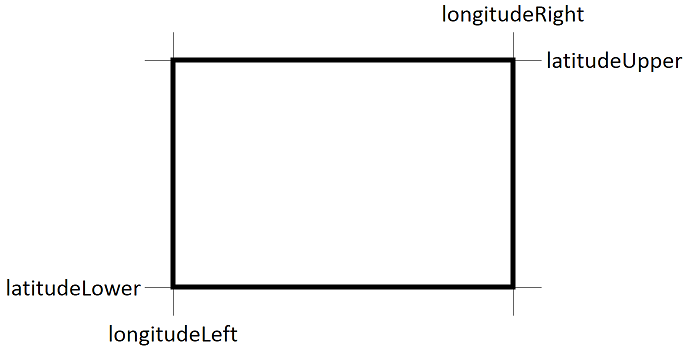
Optionally, the area of use can be constrained. Decimal values are expected in degrees latitude, longitude referring to the WGS 84 CRS. The four values span a bounding box in spherical coordinates:
Let us run an example with the following constraints:
- Only return CRSs which are bound to a cartographic transformation to WGS 84 or based on WGS 84. This becomes a query constraint.
- Only return CRSs which are based on NAD27, EPSG, or 4267. This becomes a query constraint.
- Longitude range between 100°W and 80°W [-100, -80].
- Latitude range between 20°N and 50°N [20, 50].
- Limit the response to the first two items in the catalog.
- Request that returned data contains the JSON structure of the essence rather than the persistable reference (default).
| Parameter | Example value in path | Notes |
|---|---|---|
| {longitudeLeft} | -100 | In degrees; negative W, positive E, range [-180,180] |
| {latitudeLower} | 20 | In degrees; negative S, positive N, range [-90,90] |
| {longitudeRight} | -80 | In degrees; negative W, positive E, range [-180,180] |
| {latitudeUpper} | 50 | In degrees; negative S, positive N, range [-90,90] |
| {offset} | 0 | Default 0 |
| {limit} | 2 | Default 100 |
| {mode} | persistable_reference | What kind of response? (default) populates namedReference with name and persistable reference string. |
| {mode} | essence | Populates essence property with structured contents. |
| {mode} | persistable_and_essence | Populates both namedReference and essence. |
Query constraint passed using the request body (JSON encoded). For valid search keywords, see the keyword table below:
{
  "query": "baseCRS.code:4267 transformationReady:true"
}
The query with the example values below:
POST /api/v2/search/crs?longitudeLeft=-100&latitudeLower=20&longitudeRight=-80&latitudeUpper=50&offset=0&limit=2&mode=essenceCURL search command
curl --request POST \
  --url '{root-url}/api/v2/search/crs?mode=essence&limit=2&offset=0&longitudeLeft=-100&longitudeRight=-80&latitudeLower=20&latitudeUpper=50' \
  --header 'Authorization: Bearer {Java-Web-Token}' \
  --header 'Content-Type: application/json' \
  -d '{
    "query": "baseCRS.code:4267 transformationReady:true"
  }'
Try this example by opening the API catalog in another window. The request with the parameters above creates the following response:
Response example
{
  "offset": 0,
  "count": 2,
  "totalCount": 49,
  "crses": [
    {
      "description": "NAD_1927_StatePlane_Louisiana_North_FIPS_1701 bound to NAD_1927_To_WGS_1984_79_CONUS [26781,15851]",
      "lastModified": "20170614",
      "aliasNames": [
        "LA-N",
        "SPCS27_1701"
      ],
      "namedReference": null,
      "source": "SIS factory catalog",
      "numberOfAxes": 2,
      "axisUnits": [
        "{\"measurement\":{\"ancestry\":\"Length\",\"type\":\"UM\"},\"scaleOffset\":{\"offset\":0.0,\"scale\":0.3048006096012192},\"symbol\":\"ftUS\",\"type\":\"USO\"}",
        "{\"measurement\":{\"ancestry\":\"Length\",\"type\":\"UM\"},\"scaleOffset\":{\"offset\":0.0,\"scale\":0.3048006096012192},\"symbol\":\"ftUS\",\"type\":\"USO\"}"
      ],
      "deprecationInfo": null,
      "essence": {
        "authCode": {
          "auth": "OSDU",
          "code": "26781079"
        },
        "type": "EBC",
        "ver": "PE_10_3_1",
        "name": "NAD27 * OGP-Usa Conus / Louisiana North [26781,15851]",
        "lateBoundCRS": {
          "authCode": {
            "auth": "EPSG",
            "code": "26781"
          },
          "type": "LBC",
          "ver": "PE_10_3_1",
          "name": "NAD_1927_StatePlane_Louisiana_North_FIPS_1701",
          "wkt": "PROJCS[\"NAD_1927_StatePlane_Louisiana_North_FIPS_1701\",GEOGCS[\"GCS_North_American_1927\",DATUM[\"D_North_American_1927\",SPHEROID[\"Clarke_1866\",6378206.4,294.9786982]],PRIMEM[\"Greenwich\",0.0],UNIT[\"Degree\",0.0174532925199433]],PROJECTION[\"Lambert_Conformal_Conic\"],PARAMETER[\"False_Easting\",2000000.0],PARAMETER[\"False_Northing\",0.0],PARAMETER[\"Central_Meridian\",-92.5],PARAMETER[\"Standard_Parallel_1\",31.1666666666667],PARAMETER[\"Standard_Parallel_2\",32.6666666666667],PARAMETER[\"Latitude_Of_Origin\",30.6666666666667],UNIT[\"Foot_US\",0.304800609601219],AUTHORITY[\"EPSG\",26781]]"
        },
        "singleCT": {
          "authCode": {
            "auth": "EPSG",
            "code": "15851"
          },
          "type": "ST",
          "ver": "PE_10_3_1",
          "name": "NAD_1927_To_WGS_1984_79_CONUS",
          "wkt": "GEOGTRAN[\"NAD_1927_To_WGS_1984_79_CONUS\",GEOGCS[\"GCS_North_American_1927\",DATUM[\"D_North_American_1927\",SPHEROID[\"Clarke_1866\",6378206.4,294.9786982]],PRIMEM[\"Greenwich\",0.0],UNIT[\"Degree\",0.0174532925199433]],GEOGCS[\"GCS_WGS_1984\",DATUM[\"D_WGS_1984\",SPHEROID[\"WGS_1984\",6378137.0,298.257223563]],PRIMEM[\"Greenwich\",0.0],UNIT[\"Degree\",0.0174532925199433]],METHOD[\"NADCON\"],PARAMETER[\"Dataset_conus\",0.0],AUTHORITY[\"EPSG\",15851]]"
        },
        "compoundCT": null
      },
      "transformationReady": true,
      "crstype": "Projected",
      "baseCRSAuthorityCode": {
        "auth": "EPSG",
        "code": "4267"
      },
      "areaOfUse": {
        "description": "United States (USA) - Louisiana - counties of Avoyelles; Bienville; Bossier; Caddo; Caldwell; Catahoula; Claiborne; Concordia; De Soto; East Carroll; Franklin; Grant; Jackson; La Salle; Lincoln; Madison; Morehouse; Natchitoches; Ouachita; Rapides; Red River; Richland; Sabine; Tensas; Union; Vernon; Webster; West Carroll; Winn.",
        "lastModified": "20140501",
        "aliasNames": [],
        "namedReference": null,
        "name": "USA - Louisiana - SPCS - N",
        "deprecationInfo": null,
        "essence": {
          "name": null,
          "authCode": {
            "auth": "EPSG",
            "code": "2204"
          },
          "type": "AOU",
          "boundBox": {
            "lonMin": -94.05,
            "latMin": 30.85,
            "lonMax": -90.86,
            "latMax": 33.03
          }
        }
      }
    },
    {
      "description": "NAD_1927_StatePlane_Texas_North_FIPS_4201 bound to NAD_1927_To_WGS_1984_79_CONUS [32037,15851]",
      "lastModified": "20170614",
      "aliasNames": [
        "SPCS27_4201",
        "TX-N"
      ],
      "namedReference": null,
      "source": "SIS factory catalog",
      "numberOfAxes": 2,
      "axisUnits": [
        "{\"measurement\":{\"ancestry\":\"Length\",\"type\":\"UM\"},\"scaleOffset\":{\"offset\":0.0,\"scale\":0.3048006096012192},\"symbol\":\"ftUS\",\"type\":\"USO\"}",
        "{\"measurement\":{\"ancestry\":\"Length\",\"type\":\"UM\"},\"scaleOffset\":{\"offset\":0.0,\"scale\":0.3048006096012192},\"symbol\":\"ftUS\",\"type\":\"USO\"}"
      ],
      "deprecationInfo": null,
      "essence": {
        "authCode": {
          "auth": "OSDU",
          "code": "32037079"
        },
        "type": "EBC",
        "ver": "PE_10_3_1",
        "name": "NAD27 * OGP-Usa Conus / Texas North [32037,15851]",
        "lateBoundCRS": {
          "authCode": {
            "auth": "EPSG",
            "code": "32037"
          },
          "type": "LBC",
          "ver": "PE_10_3_1",
          "name": "NAD_1927_StatePlane_Texas_North_FIPS_4201",
          "wkt": "PROJCS[\"NAD_1927_StatePlane_Texas_North_FIPS_4201\",GEOGCS[\"GCS_North_American_1927\",DATUM[\"D_North_American_1927\",SPHEROID[\"Clarke_1866\",6378206.4,294.9786982]],PRIMEM[\"Greenwich\",0.0],UNIT[\"Degree\",0.0174532925199433]],PROJECTION[\"Lambert_Conformal_Conic\"],PARAMETER[\"False_Easting\",2000000.0],PARAMETER[\"False_Northing\",0.0],PARAMETER[\"Central_Meridian\",-101.5],PARAMETER[\"Standard_Parallel_1\",34.65],PARAMETER[\"Standard_Parallel_2\",36.1833333333333],PARAMETER[\"Latitude_Of_Origin\",34.0],UNIT[\"Foot_US\",0.304800609601219],AUTHORITY[\"EPSG\",32037]]"
        },
        "singleCT": {
          "authCode": {
            "auth": "EPSG",
            "code": "15851"
          },
          "type": "ST",
          "ver": "PE_10_3_1",
          "name": "NAD_1927_To_WGS_1984_79_CONUS",
          "wkt": "GEOGTRAN[\"NAD_1927_To_WGS_1984_79_CONUS\",GEOGCS[\"GCS_North_American_1927\",DATUM[\"D_North_American_1927\",SPHEROID[\"Clarke_1866\",6378206.4,294.9786982]],PRIMEM[\"Greenwich\",0.0],UNIT[\"Degree\",0.0174532925199433]],GEOGCS[\"GCS_WGS_1984\",DATUM[\"D_WGS_1984\",SPHEROID[\"WGS_1984\",6378137.0,298.257223563]],PRIMEM[\"Greenwich\",0.0],UNIT[\"Degree\",0.0174532925199433]],METHOD[\"NADCON\"],PARAMETER[\"Dataset_conus\",0.0],AUTHORITY[\"EPSG\",15851]]"
        },
        "compoundCT": null
      },
      "transformationReady": true,
      "crstype": "Projected",
      "baseCRSAuthorityCode": {
        "auth": "EPSG",
        "code": "4267"
      },
      "areaOfUse": {
        "description": "United States (USA) - Texas - counties of: Armstrong; Briscoe; Carson; Castro; Childress; Collingsworth; Dallam; Deaf Smith; Donley; Gray; Hall; Hansford; Hartley; Hemphill; Hutchinson; Lipscomb; Moore; Ochiltree; Oldham; Parmer; Potter; Randall; Roberts; Sherman; Swisher; Wheeler.",
        "lastModified": "20140501",
        "aliasNames": [],
        "namedReference": null,
        "name": "USA - Texas - SPCS - N",
        "deprecationInfo": null,
        "essence": {
          "name": null,
          "authCode": {
            "auth": "EPSG",
            "code": "2253"
          },
          "type": "AOU",
          "boundBox": {
            "lonMin": -103.03,
            "latMin": 34.3,
            "lonMax": -99.99,
            "latMax": 36.5
          }
        }
      }
    }
  ]
}When populating a multi-purpose CRS selector, this method offers access to all CRSs of any sub-type as defined in the catalog:
GET /api/v2/crs?offset={offset}&limit={limit}| Parameter | Value |
|---|---|
| {offset} | 0 (default 0) |
| {limit} | 1000 (default 100, -1 for all) |
| {mode} | What kind of response persistable_reference (default), populates namedReference or essence, populates essence property or persistable_and_essence to have both namedReference and essence populated. |
Open Try it out: get-all-crs The response structure is of type CRSResults, which is the same structure as for the search use case above.
CURL get all CRS command
curl --request GET \
  --url '{root-url}/api/v2/crs?limit=1000&offset=0&mode=essence' \
--header 'Authorization: Bearer {Java-Web-Token}'In some cases apps may want to cache the entire catalog of coordinate reference systems and cartographic transforms. The CRS catalog service supports this with the following two methods:
/catalogto request the catalog summary. Open Try it out in a new window. The response is of type Catalog./catalog/attributesto request the last modification date of the catalog. Open Try it out in a new window. The response if of type CatalogAttributes.
The latter method allows apps to determine when the cached contents has become stale and needs a refresh.
The following table associates the arrays with the appropriate API methods to populate.
| Array/List | Type | Count | API | Description |
|---|---|---|---|---|
| lateBoundCRSes | list[LateBoundCRS] | lateBoundCRSesCount | Try it out: get-all-lateboundcrs | The list of late-bound coordinate reference systems. |
| earlyBoundCRSes | list[EarlyBoundCRS] | earlyBoundCRSesCount | [Try it out: get-all-earlyboundcrs]Try it out in a new window | The list of early-bound coordinate reference systems. |
| compoundCRSes | list[CompoundCRS] | compoundCRSesCount | Try it out: get-all-compoundcrs | The list of compound coordinate reference systems. |
| singleCTs | list[SingleCT] | singleCTsCount | Try it out: get-all-singlect | The list of single cartographic transforms. |
| compoundCTs | list[CompoundCT] | compoundCTsCount | [Try it out: get-all-compoundct] (../apis/OSDU-CRS-Catalog-Service-V2.yaml) | The list of compound cartographic transforms. |
| areaOfUses | list[AreaOfUse] | areaOfUseCount | Try it out: get-all-areas-use< | The list of areas of use. |
| Header | Description |
|---|---|
| data-partition-id (Required) | Specify the desired accessible partition ID. Only one data partition can be specified at a time. |
| correlation-id (Optional) | Used to track a single request throughout all the services it passes through. This can be a GUID in the header with a key. If you are the service initiating the request, you should generate the ID. Otherwise, you should just forward it on in the request. |
The Data Platform stores data in different data partitions, depending on the access to those data partitions in the OSDU system.
Note: Viewers permission to the provided data-partition is required to use these APIs.
The following table lists the keyword codes for the Lucene style query elements.
| Keyword code | Constrain by | Values in use or example |
|---|---|---|
name: | Specific words/sub-strings in the name | Example: name:*ED50* |
description: | Specific sub-strings in the description | |
type: | Type code for the CRS | type:LBCRS (late-bound or un-bound CRS), type:EBCRS (early-bound CRS), type:CCRS (compound CRS) |
authority: | Authority | Example: authority:EPSG |
code: | Authority code number | Example: code:4326 |
deprecationState: | State of deprecation | deprecationState:identical (can be swapped) or deprecationState:corrected non-trivial deprecation |
remarks: | Specific sub-strings in the deprecation remarks | Example: remarks:Deprecated |
lastModified: | Specific last modification dates | Example: lastModified:20070827 |
source: | CRS source | Example: source:OGP |
wellKnownText: | Specific words/sub-strings in the well-known text (late-bound or un-bound CRSs only) | Example: wellKnownText:*Clarke_1880_RGS* |
crsType: | Coordinate Reference System (CRS) type | Example: crsType:"Compound Projected" |
baseCRS.authority: | Projected CRS's base CRS authority | Example: baseCRS.authority:EPSG |
baseCRS.code: | Projected CRS's base CRS authority code | Example: baseCRS.code:4267 (NAD27) |
horizontalCRS.authority: | Compound CRS's horizontal CRS authority | Example: horizontalCRS.authority:EPSG |
horizontalCRS.code: | Compound CRS's horizontal CRS authority code | Example: horizontalCRS.code:32615 |
verticalCRS.authority: | Compound CRS's vertical CRS authority | Example: verticalCRS.authority:EPSG |
verticalCRS.code: | Compound CRS's vertical CRS authority code | Example: verticalCRS.code:5773 |
lateBoundCRS.authority: | Early-bound CRS's (late-bound) CRS authority | Example: lateBoundCRS.authority:EPSG |
lateBoundCRS.code: | Early-bound CRS's (late-bound) CRS authority code | Example: lateBoundCRS.code:23031 |
ct.authority: | Early-bound CRS's cartographic transform authority | Example: ct.authority:EPSG |
ct.code: | Early-bound CRS's cartographic transform authority code | Example: ct.code:1612 |
transformationReady: | CRS's transformation readiness, i.e. is the CRS ready to be used in datum transformations (true or false) | transformationReady:true or transformationReady:false |
The following table lists the keyword codes for the Lucene style query elements.
| Keyword code | Constrain by | Values in use or example |
|---|---|---|
name: | Specific words/sub-strings in the name | Example: name:*NAD_1927* |
description: | Specific sub-strings in the description | |
type: | Type code for the Cartographic Transform (CT) | type:ST (single CT), type:CT (compound CT) |
authority: | Authority | Example: authority:EPSG |
code: | Authority code number | Example: code:15851 |
deprecationState: | State of deprecation | deprecationState:identical (can be swapped) or deprecationState:corrected non-trivial deprecation |
remarks: | Specific sub-strings in the deprecation remarks | Example: remarks:*PE_10_1_0* |
lastModified: | Specific last modification dates | Example: lastModified:20180611 |
source: | CT source | Example: source:OGP |
wellKnownText: | Specific words/sub-strings in the well-known text (late-bound or un-bound CRSs only) | Example: wellKnownText:*Dataset_conus* |
fromCRS.authority: | Source CRS authority | fromCRS.authority:EPSG |
fromCRS.code: | Source CRS code | fromCRS.code:4267 |
toCRS.authority: | Target CRS authority | toCRS.authority:EPSG |
toCRS.code: | Target CRS code | toCRS.code:4328 |
policy: | Compound transformation policy | policy:fallback or policy:concatenated |
The following table lists the keyword codes for the Lucene style query elements. The keywords apply to all API versions.
| Keyword code | Constrain by | Values in use or example |
|---|---|---|
name: | Specific words/sub-strings in the name | Example: name:*America* |
description: | Specific sub-strings in the description | Example: description:*DMA ED50* |
authority: | Authority | Example: authority:OSDU |
code: | Authority code number | Example: code:2205 |
deprecationState: | State of deprecation | deprecationState:identical (can be swapped) or deprecationState:corrected non-trivial deprecation |
remarks: | Specific sub-strings in the deprecation remarks | |
lastModified: | Specific last modification dates | Example: lastModified:20180611 |
| Name | Type | Description | Notes |
|---|---|---|---|
| areaOfUseCount | int | The total number of areas of use in the catalog. | [optional] |
| areaOfUses | list[AreaOfUse] | The complete list of areas of use. | [optional] |
| attributes | CatalogAttributes | The name and last modification time of the catalog. | [optional] |
| compoundCTsCount | int | The total number of compoundCTs in the catalog. | [optional] |
| compoundCTs | list[CompoundCT] | The complete list of compound cartographic transforms. | [optional] |
| compoundCRSesCount | int | The total number of compoundCRSes in the catalog. | [optional] |
| compoundCRSes | list[CompoundCRS] | The complete list of compound coordinate reference systems. | [optional] |
| earlyBoundCRSesCount | int | The total number of earlyBoundCRSes in the catalog. | [optional] |
| earlyBoundCRSes | list[EarlyBoundCRS] | The complete list of early-bound coordinate reference systems. | [optional] |
| lateBoundCRSesCount | int | The total number of lateBoundCRSes in the catalog. | [optional] |
| lateBoundCRSes | list[LateBoundCRS] | The complete list of late-bound coordinate reference systems. | [optional] |
| singleCTsCount | int | The total number of singleCTs in the catalog. | [optional] |
| singleCTs | list[SingleCT] | The complete list of single cartographic transforms. | [optional] |
Catalog example
{
  "lateBoundCRSes": [],
  "lateBoundCRSesCount": 1151,
  "earlyBoundCRSes": [],
  "earlyBoundCRSesCount": 1059,
  "compoundCRSesCount": 60,
  "singleCTs": [],
  "singleCTsCount": 227,
  "compoundCTs": [],
  "compoundCTsCount": 1,
  "areaOfUseCount": 953,
  "attributes": {
    "name": "Minimal EPSG standard catalog",
    "description": "Catalog containing selected ESRI's standard EPSG coordinate reference systems and cartographic transforms, and limited early-bound coordinate reference systems where the CRS and TRF area-of-use intersect, augmented by Ocean factory catalog standard definitions."
    "lastModified": "2018-06-11T15:39:55.1229803Z"
  },
  "areasOfUse": [],
  "compoundCRSes": []
}
Back to API data structures - Back to table of contents
| Name | Type | Description | Notes |
|---|---|---|---|
| description | str | [optional] | |
| lastModified | str | The last modification date and time (UTC) of this catalog. | [optional] |
| name | str | Name of the catalog. | [optional] |
Back to API data structures - Back to table of contents
| Name | Type | Description | Notes |
|---|---|---|---|
| crstype | str | The type of the LateBoundCRS. | [optional] |
| source | str | The source of the LateBoundCRS. | [optional] |
| transformationReady | bool | The transformation readiness of the LateBoundCRS. | [optional] |
| baseCRSAuthorityCode | AuthCode | The base authority code of the LateBoundCRS. | [optional] |
| aliasNames | list[str] | Alias names for this LateBoundCRS. | [optional] |
| axisUnits | list[str] | Axis unit essences. | [optional] |
| numberOfAxes | int | The NumberOfAxes of the LateBoundCRS. | [optional] |
| description | str | The description of the LateBoundCRS. | [optional] |
| lastModified | str | The LastModified of the LateBoundCRS. | [optional] |
| areaOfUse | AreaOfUse | The area of use for this CRS. | [optional] |
| deprecationInfo | CRSDeprecationInfo | Only if deprecated - additional information and potentially a recommended replacement CRS. | [optional] |
| namedReference | NamedReference | A structure containing the item "Name" and the persistable reference string; populated if the request mode='persistableReference'. | [optional] |
| essence | LateBoundCRSEssence | The essence of the LateBoundCRS; populated if the request mode='essence'. | [optional] |
LateBoundCRS example
{
  "description": "CRS Scope: Geodetic survey.",
  "lastModified": "20040106",
  "aliasNames": [
    "Pointe Noire",
    "Congo 1960 Pointe Noire"
  ],
  "namedReference": {
    "name": "GCS_Pointe_Noire",
    "persistableReference": "{\"wkt\":\"GEOGCS[\\\"GCS_Pointe_Noire\\\",DATUM[\\\"D_Pointe_Noire\\\",SPHEROID[\\\"Clarke_1880_IGN\\\",6378249.2,293.466021293627]],PRIMEM[\\\"Greenwich\\\",0.0],UNIT[\\\"Degree\\\",0.0174532925199433],AUTHORITY[\\\"EPSG\\\",4282]]\",\"ver\":\"PE_10_3_1\",\"name\":\"GCS_Pointe_Noire\",\"authCode\":{\"auth\":\"EPSG\",\"code\":\"4282\"},\"type\":\"LBC\"}"
  },
  "source": "",
  "numberOfAxes": 2,
  "axisUnits": [
    "{\"measurement\":{\"ancestry\":\"Plane_Angle\",\"type\":\"UM\"},\"scaleOffset\":{\"offset\":0.0,\"scale\":0.0174532925199433},\"symbol\":\"dega\",\"type\":\"USO\"}",
    "{\"measurement\":{\"ancestry\":\"Plane_Angle\",\"type\":\"UM\"},\"scaleOffset\":{\"offset\":0.0,\"scale\":0.0174532925199433},\"symbol\":\"dega\",\"type\":\"USO\"}"
  ],
  "deprecationInfo": null,
  "essence": {
    "authCode": {
      "auth": "EPSG",
      "code": "4282"
    },
    "type": "LBC",
    "ver": "PE_10_3_1",
    "name": "GCS_Pointe_Noire",
    "wkt": "GEOGCS[\"GCS_Pointe_Noire\",DATUM[\"D_Pointe_Noire\",SPHEROID[\"Clarke_1880_IGN\",6378249.2,293.466021293627]],PRIMEM[\"Greenwich\",0.0],UNIT[\"Degree\",0.0174532925199433],AUTHORITY[\"EPSG\",4282]]"
  },
  "transformationReady": false,
  "crstype": "Geographic2D",
  "baseCRSAuthorityCode": null,
  "areaOfUse": {
    "description": "Congo - onshore and offshore.",
    "lastModified": "20140501",
    "aliasNames": [],
    "namedReference": null,
    "name": "Congo",
    "deprecationInfo": null,
    "essence": {
      "name": null,
      "authCode": {
        "auth": "EPSG",
        "code": "1072"
      },
      "type": "AOU",
      "boundBox": {
        "lonMin": 8.84,
        "latMin": -6.91,
        "lonMax": 18.65,
        "latMax": 3.72
      }
    }
  }
}
Back to API data structures - Back to table of contents
| Name | Type | Description | Notes |
|---|---|---|---|
| type | str | The type identifier, fixed to 'LBC'. | [default to 'LBC'] |
| name | str | The name of the late-bound coordinate reference system. | |
| ver | str | The engine version issuing the definition. | [optional] |
| wkt | str | Well-known text (Esri style) of the late-bound coordinate reference system. | |
| authCode | AuthCode | The authority code for this item. | [optional] |
Back to API data structures - Back to table of contents
| Name | Type | Description | Notes |
|---|---|---|---|
| crsType | str | The type of the EarlyBoundCRS. | [optional] |
| source | str | The source of the EarlyBoundCRS. | [optional] |
| transformationReady | bool | The transformation readiness of the EarlyBoundCRS, meaning: can data be transformed to WGS 84? | [optional] |
| baseCRSAuthorityCode | AuthCode | The base authority code of the LateBoundCRS. | [optional] |
| aliasNames | list[str] | Alias names for this EarlyBoundCRS. | [optional] |
| axisUnits | list[str] | Axis unit essences. | [optional] |
| numberOfAxes | int | The NumberOfAxes of the EarlyBoundCRS. | [optional] |
| description | str | The description of the EarlyBoundCRS. | [optional] |
| lastModified | str | The LastModified of the EarlyBoundCRS. | [optional] |
| areaOfUse | AreaOfUse | The area of use for this CRS. | [optional] |
| deprecationInfo | CRSDeprecationInfo | Only if deprecated - additional information and potentially a recommended replacement CRS. | [optional] |
| namedReference | NamedReference | A structure containing the item name and the persistable Reference string; populated if the request mode='persistableReference'. | [optional] |
| essence | EarlyBoundCRSEssence | The essence of the EarlyBoundCRS. | [optional] |
EarlyBoundCRS example
{
  "description": "ED_1950_UTM_Zone_31N bound to ED_1950_To_WGS_1984_24 [23031,1613]",
  "lastModified": "20180611",
  "aliasNames": [],
  "namedReference": {
    "name": "ED50 * EPSG-Nor S62 2001 / UTM zone 31N [23031,1613]",
    "persistableReference": "{\"lateBoundCRS\":{\"wkt\":\"PROJCS[\\\"ED_1950_UTM_Zone_31N\\\",GEOGCS[\\\"GCS_European_1950\\\",DATUM[\\\"D_European_1950\\\",SPHEROID[\\\"International_1924\\\",6378388.0,297.0]],PRIMEM[\\\"Greenwich\\\",0.0],UNIT[\\\"Degree\\\",0.0174532925199433]],PROJECTION[\\\"Transverse_Mercator\\\"],PARAMETER[\\\"False_Easting\\\",500000.0],PARAMETER[\\\"False_Northing\\\",0.0],PARAMETER[\\\"Central_Meridian\\\",3.0],PARAMETER[\\\"Scale_Factor\\\",0.9996],PARAMETER[\\\"Latitude_Of_Origin\\\",0.0],UNIT[\\\"Meter\\\",1.0],AUTHORITY[\\\"EPSG\\\",23031]]\",\"ver\":\"PE_10_3_1\",\"name\":\"ED_1950_UTM_Zone_31N\",\"authCode\":{\"auth\":\"EPSG\",\"code\":\"23031\"},\"type\":\"LBC\"},\"singleCT\":{\"wkt\":\"GEOGTRAN[\\\"ED_1950_To_WGS_1984_24\\\",GEOGCS[\\\"GCS_European_1950\\\",DATUM[\\\"D_European_1950\\\",SPHEROID[\\\"International_1924\\\",6378388.0,297.0]],PRIMEM[\\\"Greenwich\\\",0.0],UNIT[\\\"Degree\\\",0.0174532925199433]],GEOGCS[\\\"GCS_WGS_1984\\\",DATUM[\\\"D_WGS_1984\\\",SPHEROID[\\\"WGS_1984\\\",6378137.0,298.257223563]],PRIMEM[\\\"Greenwich\\\",0.0],UNIT[\\\"Degree\\\",0.0174532925199433]],METHOD[\\\"Position_Vector\\\"],PARAMETER[\\\"X_Axis_Translation\\\",-90.365],PARAMETER[\\\"Y_Axis_Translation\\\",-101.13],PARAMETER[\\\"Z_Axis_Translation\\\",-123.384],PARAMETER[\\\"X_Axis_Rotation\\\",0.333],PARAMETER[\\\"Y_Axis_Rotation\\\",0.077],PARAMETER[\\\"Z_Axis_Rotation\\\",0.894],PARAMETER[\\\"Scale_Difference\\\",1.994],AUTHORITY[\\\"EPSG\\\",1613]]\",\"ver\":\"PE_10_3_1\",\"name\":\"ED_1950_To_WGS_1984_24\",\"authCode\":{\"auth\":\"EPSG\",\"code\":\"1613\"},\"type\":\"ST\"},\"ver\":\"PE_10_3_1\",\"name\":\"ED50 * EPSG-Nor S62 2001 / UTM zone 31N [23031,1613]\",\"authCode\":{\"auth\":\"OSDU\",\"code\":\"23031024\"},\"type\":\"EBC\"}"
  },
  "source": "Ocean catalog",
  "numberOfAxes": 2,
  "axisUnits": [
    "{\"measurement\":{\"ancestry\":\"Length\",\"type\":\"UM\"},\"scaleOffset\":{\"offset\":0.0,\"scale\":1.0},\"symbol\":\"m\",\"type\":\"USO\"}",
    "{\"measurement\":{\"ancestry\":\"Length\",\"type\":\"UM\"},\"scaleOffset\":{\"offset\":0.0,\"scale\":1.0},\"symbol\":\"m\",\"type\":\"USO\"}"
  ],
  "deprecationInfo": null,
  "essence": {
    "authCode": {
      "auth": "OSDU",
      "code": "23031024"
    },
    "type": "EBC",
    "ver": "PE_10_3_1",
    "name": "ED50 * EPSG-Nor S62 2001 / UTM zone 31N [23031,1613]",
    "lateBoundCRS": {
      "authCode": {
        "auth": "EPSG",
        "code": "23031"
      },
      "type": "LBC",
      "ver": "PE_10_3_1",
      "name": "ED_1950_UTM_Zone_31N",
      "wkt": "PROJCS[\"ED_1950_UTM_Zone_31N\",GEOGCS[\"GCS_European_1950\",DATUM[\"D_European_1950\",SPHEROID[\"International_1924\",6378388.0,297.0]],PRIMEM[\"Greenwich\",0.0],UNIT[\"Degree\",0.0174532925199433]],PROJECTION[\"Transverse_Mercator\"],PARAMETER[\"False_Easting\",500000.0],PARAMETER[\"False_Northing\",0.0],PARAMETER[\"Central_Meridian\",3.0],PARAMETER[\"Scale_Factor\",0.9996],PARAMETER[\"Latitude_Of_Origin\",0.0],UNIT[\"Meter\",1.0],AUTHORITY[\"EPSG\",23031]]"
    },
    "singleCT": {
      "authCode": {
        "auth": "EPSG",
        "code": "1613"
      },
      "type": "ST",
      "ver": "PE_10_3_1",
      "name": "ED_1950_To_WGS_1984_24",
      "wkt": "GEOGTRAN[\"ED_1950_To_WGS_1984_24\",GEOGCS[\"GCS_European_1950\",DATUM[\"D_European_1950\",SPHEROID[\"International_1924\",6378388.0,297.0]],PRIMEM[\"Greenwich\",0.0],UNIT[\"Degree\",0.0174532925199433]],GEOGCS[\"GCS_WGS_1984\",DATUM[\"D_WGS_1984\",SPHEROID[\"WGS_1984\",6378137.0,298.257223563]],PRIMEM[\"Greenwich\",0.0],UNIT[\"Degree\",0.0174532925199433]],METHOD[\"Position_Vector\"],PARAMETER[\"X_Axis_Translation\",-90.365],PARAMETER[\"Y_Axis_Translation\",-101.13],PARAMETER[\"Z_Axis_Translation\",-123.384],PARAMETER[\"X_Axis_Rotation\",0.333],PARAMETER[\"Y_Axis_Rotation\",0.077],PARAMETER[\"Z_Axis_Rotation\",0.894],PARAMETER[\"Scale_Difference\",1.994],AUTHORITY[\"EPSG\",1613]]"
    },
    "compoundCT": null
  },
  "transformationReady": true,
  "crstype": "Projected",
  "baseCRSAuthorityCode": {
    "auth": "EPSG",
    "code": "4230"
  },
  "areaOfUse": {
    "description": "Intersection of Europe - 0°E to 6°E and ED50 by country [1634] and Norway - North Sea - offshore south of 62°N [2334]",
    "lastModified": "20180611",
    "aliasNames": [],
    "namedReference": null,
    "name": "Europe - 0°E to 6°E and ED50 by country, Norway - North Sea - offshore south of 62°N",
    "deprecationInfo": null,
    "essence": {
      "name": null,
      "authCode": {
        "auth": "OSDU",
        "code": "16342334"
      },
      "type": "AOU",
      "boundBox": {
        "lonMin": 1.37,
        "latMin": 56.08,
        "lonMax": 6.01,
        "latMax": 62
      }
    }
  }
}
Back to API data structures - Back to table of contents
| Name | Type | Description | Notes |
|---|---|---|---|
| type | str | The type identifier, fixed to 'EBC'. | [default to 'EBC'] |
| name | str | The name of the early-bound coordinate reference system. | |
| ver | str | The engine version issuing the definition. | [optional] |
| lateBoundCRS | LateBoundCRSEssence | Late-bound CRS, which is bound to a single (st) or compound (ct) transformation to WGS 84. | |
| single_ct | SingleCTEssence | Single transformation, which binds the late-bound CRS (lb) to WGS 84. If absent, a compound transformation (ct) must be present. | [optional] |
| compound_ct | CompoundCTEssence | Compound transformation, which binds the late-bound CRS (lb) to WGS 84. If absent, a single transformation (st) must be present. | [optional] |
| auth_code | AuthCode | The authority code for this item. | [optional] |
Back to API data structures - Back to table of contents
| Name | Type | Description | Notes |
|---|---|---|---|
| crstype | str | The type of the CompoundCRS. | [optional] |
| source | str | The source of the CompoundCRS. | [optional] |
| transformationReady | bool | The transformation readiness of the CompoundCRS, meaning: can data be transformed to WGS 84? | [optional] |
| baseCRSAuthorityCode | AuthCode | The base authority code of the LateBoundCRS. | [optional] |
| aliasNames | list[str] | Alias names for this CompoundCRS. | [optional] |
| axisUnits | list[str] | Axis unit essences. | [optional] |
| numberOfAxes | int | The NumberOfAxes of the CompoundCRS. | [optional] |
| description | str | The description of the CompoundCRS. | [optional] |
| lastModified | str | The LastModified of the CompoundCRS. | [optional] |
| areaOfUse | AreaOfUse | The area of use for this CRS. | [optional] |
| deprecationInfo | CRSDeprecationInfo | Only if deprecated - additional information and potentially a recommended replacement CRS. | [optional] |
| namedReference | NamedReference | A structure containing the item name and the persistable reference string; populated if the request mode='persistableReference'. | [optional] |
| essence | CompoundCRSEssence | The essence of the CompoundCRS. | [optional] |
CompoundCRS example
{
  "description": "Horizontal CRS: CRS Scope: Large and medium scale topographic mapping and engineering survey.; Vertical CRS: CRS Scope: Geodesy. | Remarks: Zero-height surface resulting from the application of the EGM96 geoid model to the WGS 84 ellipsoid. Replaces EGM84 height (CRS code 5798). Replaced by EGM2008 height (CRS code 3855). | Information Source: NASA http://cddis.gsfc.nasa.gov/926/egm96/egm96.html",
  "lastModified": "20180611",
  "aliasNames": [],
  "namedReference": {
    "name": "WGS 84 / UTM zone 31N + EGM96 height",
    "persistableReference": "{\"horzLateBoundCRS\":{\"wkt\":\"PROJCS[\\\"WGS_1984_UTM_Zone_31N\\\",GEOGCS[\\\"GCS_WGS_1984\\\",DATUM[\\\"D_WGS_1984\\\",SPHEROID[\\\"WGS_1984\\\",6378137.0,298.257223563]],PRIMEM[\\\"Greenwich\\\",0.0],UNIT[\\\"Degree\\\",0.0174532925199433]],PROJECTION[\\\"Transverse_Mercator\\\"],PARAMETER[\\\"False_Easting\\\",500000.0],PARAMETER[\\\"False_Northing\\\",0.0],PARAMETER[\\\"Central_Meridian\\\",3.0],PARAMETER[\\\"Scale_Factor\\\",0.9996],PARAMETER[\\\"Latitude_Of_Origin\\\",0.0],UNIT[\\\"Meter\\\",1.0],AUTHORITY[\\\"EPSG\\\",32631]]\",\"ver\":\"PE_10_3_1\",\"name\":\"WGS_1984_UTM_Zone_31N\",\"authCode\":{\"auth\":\"EPSG\",\"code\":\"32631\"},\"type\":\"LBC\"},\"vertLateBoundCRS\":{\"wkt\":\"VERTCS[\\\"EGM96_Geoid\\\",VDATUM[\\\"EGM96_Geoid\\\"],PARAMETER[\\\"Vertical_Shift\\\",0.0],PARAMETER[\\\"Direction\\\",1.0],UNIT[\\\"Meter\\\",1.0],AUTHORITY[\\\"EPSG\\\",5773]]\",\"ver\":\"PE_10_3_1\",\"name\":\"EGM96_Geoid\",\"authCode\":{\"auth\":\"EPSG\",\"code\":\"5773\"},\"type\":\"LBC\"},\"ver\":\"PE_10_3_1\",\"name\":\"WGS 84 / UTM zone 31N + EGM96 height\",\"authCode\":{\"auth\":\"OSDU\",\"code\":\"326315773\"},\"type\":\"CC\"}"
  },
  "source": "Ocean catalog",
  "numberOfAxes": 3,
  "axisUnits": [
    "{\"measurement\":{\"ancestry\":\"Length\",\"type\":\"UM\"},\"scaleOffset\":{\"offset\":0.0,\"scale\":1.0},\"symbol\":\"m\",\"type\":\"USO\"}",
    "{\"measurement\":{\"ancestry\":\"Length\",\"type\":\"UM\"},\"scaleOffset\":{\"offset\":0.0,\"scale\":1.0},\"symbol\":\"m\",\"type\":\"USO\"}",
    "{\"measurement\":{\"ancestry\":\"Length\",\"type\":\"UM\"},\"scaleOffset\":{\"offset\":0.0,\"scale\":1.0},\"symbol\":\"m\",\"type\":\"USO\"}"
  ],
  "deprecationInfo": null,
  "essence": {
    "authCode": {
      "auth": "OSDU",
      "code": "326315773"
    },
    "type": "CC",
    "ver": "PE_10_3_1",
    "name": "WGS 84 / UTM zone 31N + EGM96 height",
    "horzLateBoundCRS": {
      "authCode": {
        "auth": "EPSG",
        "code": "32631"
      },
      "type": "LBC",
      "ver": "PE_10_3_1",
      "name": "WGS_1984_UTM_Zone_31N",
      "wkt": "PROJCS[\"WGS_1984_UTM_Zone_31N\",GEOGCS[\"GCS_WGS_1984\",DATUM[\"D_WGS_1984\",SPHEROID[\"WGS_1984\",6378137.0,298.257223563]],PRIMEM[\"Greenwich\",0.0],UNIT[\"Degree\",0.0174532925199433]],PROJECTION[\"Transverse_Mercator\"],PARAMETER[\"False_Easting\",500000.0],PARAMETER[\"False_Northing\",0.0],PARAMETER[\"Central_Meridian\",3.0],PARAMETER[\"Scale_Factor\",0.9996],PARAMETER[\"Latitude_Of_Origin\",0.0],UNIT[\"Meter\",1.0],AUTHORITY[\"EPSG\",32631]]"
    },
    "vertLateBoundCRS": {
      "authCode": {
        "auth": "EPSG",
        "code": "5773"
      },
      "type": "LBC",
      "ver": "PE_10_3_1",
      "name": "EGM96_Geoid",
      "wkt": "VERTCS[\"EGM96_Geoid\",VDATUM[\"EGM96_Geoid\"],PARAMETER[\"Vertical_Shift\",0.0],PARAMETER[\"Direction\",1.0],UNIT[\"Meter\",1.0],AUTHORITY[\"EPSG\",5773]]"
    },
    "horzEarlyBoundCRS": null,
    "vertEarlyBoundCRS": null
  },
  "transformationReady": false,
  "crstype": "Compound Projected Vertical",
  "baseCRSAuthorityCode": {
    "auth": "EPSG",
    "code": "4326"
  },
  "areaOfUse": {
    "description": "Between 0°E and 6°E, northern hemisphere between equator and 84°N, onshore and offshore. Algeria. Andorra. Belgium. Benin. Burkina Faso. Denmark - North Sea. France. Germany - North Sea. Ghana. Luxembourg. Mali. Netherlands. Niger. Nigeria. Norway. Spain. Togo. United Kingdom (UK) - North Sea.",
    "lastModified": "20150104",
    "aliasNames": [],
    "namedReference": null,
    "name": "World - N hemisphere - 0°E to 6°E - by country",
    "deprecationInfo": null,
    "essence": {
      "name": null,
      "authCode": {
        "auth": "EPSG",
        "code": "2060"
      },
      "type": "AOU",
      "boundBox": {
        "lonMin": 0,
        "latMin": 0,
        "lonMax": 6,
        "latMax": 84
      }
    }
  }
}
Back to API data structures - Back to table of contents
| Name | Type | Description | Notes |
|---|---|---|---|
| type | str | The type identifier. Fixed to 'CC'. | [default to 'CC'] |
| name | str | The name of the compound coordinate reference system. | |
| ver | str | The engine version issuing the definition. | [optional] |
| horzLateBoundCRS | LateBoundCRSEssence | The horizontal CRS of a compound CRS as late-bound CRS. If 'horzLateBoundCRS' is non-null, 'horzEarlyBoundCRS' must be null. | [optional] |
| horzEarlyBoundCRS | EarlyBoundCRSEssence | The horizontal CRS of a compound CRS as early-bound CRS. If 'horzEarlyBoundCRS' is non-null, 'horzLateBoundCRS' must be null. | [optional] |
| vertLateBoundCRS | LateBoundCRSEssence | The vertical CRS of the compound CRS as late-bound CRS. If 'vertLateBoundCRS' is non-null, 'vertEarlyBoundCRS' must be null. | [optional] |
| vertEarlyBoundCRS | EarlyBoundCRSEssence | The vertical CRS of the compound CRS as early-bound CRS. If 'vertEarlyBoundCRS' is non-null, 'vertLateBoundCRS' must be null. | [optional] |
| authCode | AuthCode | The authority code for this item. | [optional] |
Back to API data structures - Back to table of contents
| Name | Type | Description | Notes |
|---|---|---|---|
| source | str | The source of the SingleCT. | [optional] |
| aliasNames | list[str] | Alias names for this SingleCT. | [optional] |
| description | str | The description of the SingleCT. | [optional] |
| fromCRSAuthorityCode | AuthCode | The 'from CRS' authority code of this SingleCT. | [optional] |
| toCRSAuthorityCode | AuthCode | The 'to CRS' authority code of this SingleCT. | [optional] |
| lastModified | str | The LastModified of the SingleCT. | [optional] |
| areaOfUse | AreaOfUse | The area of use for this SingleCT. | [optional] |
| deprecationInfo | CTDeprecationInfo | Only if deprecated - additional information and potentially a recommended replacement CT. | [optional] |
| namedReference | NamedReference | A structure containing the item Name and the persistable reference string; populated if the request mode='persistableReference'. | [optional] |
| essence | SingleCTEssence | The essence of the SingleCT. | [optional] |
SingleCT example
{
  "description": "Coord Op Scope: Recommended for oil industry use in US Gulf of Mexico (GoM). Accuracy at 67% confidence level is 0.15m onshore, 5m nearshore and undetermined farther offshore. | Tfm Accuracy: 5 | Remarks: Transformation taken from NAD27 to NAD83 (1) (code 1241) assuming that NAD83 is equivalent to WGS 84 within the accuracy of this tfm. Uses NADCON method which expects longitudes positive west; EPSG CRS codes 4267 and 4326 have longitudes positive east. | Information Source: OGP",
  "lastModified": "20060306",
  "aliasNames": [
    "NAD27 to WGS 84 (79)"
  ],
  "namedReference": {
    "name": "NAD_1927_To_WGS_1984_79_CONUS",
    "persistableReference": "{\"wkt\":\"GEOGTRAN[\\\"NAD_1927_To_WGS_1984_79_CONUS\\\",GEOGCS[\\\"GCS_North_American_1927\\\",DATUM[\\\"D_North_American_1927\\\",SPHEROID[\\\"Clarke_1866\\\",6378206.4,294.9786982]],PRIMEM[\\\"Greenwich\\\",0.0],UNIT[\\\"Degree\\\",0.0174532925199433]],GEOGCS[\\\"GCS_WGS_1984\\\",DATUM[\\\"D_WGS_1984\\\",SPHEROID[\\\"WGS_1984\\\",6378137.0,298.257223563]],PRIMEM[\\\"Greenwich\\\",0.0],UNIT[\\\"Degree\\\",0.0174532925199433]],METHOD[\\\"NADCON\\\"],PARAMETER[\\\"Dataset_conus\\\",0.0],AUTHORITY[\\\"EPSG\\\",15851]]\",\"ver\":\"PE_10_3_1\",\"name\":\"NAD_1927_To_WGS_1984_79_CONUS\",\"authCode\":{\"auth\":\"EPSG\",\"code\":\"15851\"},\"type\":\"ST\"}"
  },
  "source": "OGP",
  "essence": {
    "authCode": {
      "auth": "EPSG",
      "code": "15851"
    },
    "type": "ST",
    "ver": "PE_10_3_1",
    "name": "NAD_1927_To_WGS_1984_79_CONUS",
    "wkt": "GEOGTRAN[\"NAD_1927_To_WGS_1984_79_CONUS\",GEOGCS[\"GCS_North_American_1927\",DATUM[\"D_North_American_1927\",SPHEROID[\"Clarke_1866\",6378206.4,294.9786982]],PRIMEM[\"Greenwich\",0.0],UNIT[\"Degree\",0.0174532925199433]],GEOGCS[\"GCS_WGS_1984\",DATUM[\"D_WGS_1984\",SPHEROID[\"WGS_1984\",6378137.0,298.257223563]],PRIMEM[\"Greenwich\",0.0],UNIT[\"Degree\",0.0174532925199433]],METHOD[\"NADCON\"],PARAMETER[\"Dataset_conus\",0.0],AUTHORITY[\"EPSG\",15851]]"
  },
  "toCRSAuthorityCode": {
    "auth": "EPSG",
    "code": "4326"
  },
  "fromCRSAuthorityCode": {
    "auth": "EPSG",
    "code": "4267"
  },
  "areaOfUse": {
    "description": "United States (USA) - CONUS including EEZ -onshore and offshore - Alabama; Arizona; Arkansas; California; Colorado; Connecticut; Delaware; Florida; Georgia; Idaho; Illinois; Indiana; Iowa; Kansas; Kentucky; Louisiana; Maine; Maryland; Massachusetts; Michigan; Minnesota; Mississippi; Missouri; Montana; Nebraska; Nevada; New Hampshire; New Jersey; New Mexico; New York; North Carolina; North Dakota; Ohio; Oklahoma; Oregon; Pennsylvania; Rhode Island; South Carolina; South Dakota; Tennessee; Texas; Utah; Vermont; Virginia; Washington; West Virginia; Wisconsin; Wyoming. US Gulf of Mexico (GoM) OCS.",
    "lastModified": "20140501",
    "aliasNames": [],
    "namedReference": null,
    "name": "USA - CONUS including EEZ",
    "deprecationInfo": null,
    "essence": {
      "name": null,
      "authCode": {
        "auth": "EPSG",
        "code": "2374"
      },
      "type": "AOU",
      "boundBox": {
        "lonMin": -129.17,
        "latMin": 23.81,
        "lonMax": -65.69,
        "latMax": 49.38
      }
    }
  },
  "deprecationInfo": null
}
Back to API data structures - Back to table of contents
| Name | Type | Description | Notes |
|---|---|---|---|
| type | str | The type identifier, fixed to 'ST'. | [default to 'ST'] |
| name | str | The name of the simple cartographic transformation. | |
| ver | str | The engine version issuing the definition. | [optional] |
| wkt | str | The well-known text (Esri style) defining this transformation. | |
| authCode | AuthCode | The authority code for this item. | [optional] |
Back to API data structures - Back to table of contents
| Name | Type | Description | Notes |
|---|---|---|---|
| source | str | The source of the CompoundCT. | [optional] |
| aliasNames | list[str] | Alias names for this CompoundCT. | [optional] |
| description | str | The description of the CompoundCT. | [optional] |
| fromCRSAuthorityCode | AuthCode | The 'from CRS' authority code of this CompoundCT. | [optional] |
| toCRSAuthorityCode | AuthCode | The 'to CRS' authority code of this CompoundCT. | [optional] |
| lastModified | str | The LastModified of the CompoundCT. | [optional] |
| areaOfUse | AreaOfUse | The area of use for this CompoundCT. | [optional] |
| deprecationInfo | CTDeprecationInfo | Only if deprecated - additional information and potentially a recommended replacement CT. | [optional] |
| namedReference | NamedReference | A structure containing the item Name and the persistable reference string; populated if the request mode='persistableReference'. | [optional] |
| essence | CompoundCTEssence | The essence of the CompoundCT. | [optional] |
CompoundCT example
{
  "description": "Fallback Coord Op Scope: Recommended for oil industry use in US Gulf of Mexico (GoM). Accuracy at 67% confidence level is 0.15m onshore, 5m nearshore and undetermined farther offshore. | Tfm Accuracy: 5 | Remarks: Transformation taken from NAD27 to NAD83 (1) (code 1241) assuming that NAD83 is equivalent to WGS 84 within the accuracy of this tfm. Uses NADCON method which expects longitudes positive west; EPSG CRS codes 4267 and 4326 have longitudes positive east. | Information Source: OGP/Coord Op Scope: Approximation at the +/- 1m level. | Tfm Accuracy: 1 | Remarks: Parameter file is from NAD27 to NAD83 (4) (code 1313) assuming that NAD83 is equivalent to WGS 84 within the accuracy of the transformation. | Information Source: OGP",
  "lastModified": "20180611",
  "aliasNames": [],
  "namedReference": {
    "name": "Fallback NAD27 to WGS 84 (79)/NAD27 to WGS 84 (33)",
    "persistableReference": "{\"policy\":\"Fallback\",\"cts\":[{\"wkt\":\"GEOGTRAN[\\\"NAD_1927_To_WGS_1984_79_CONUS\\\",GEOGCS[\\\"GCS_North_American_1927\\\",DATUM[\\\"D_North_American_1927\\\",SPHEROID[\\\"Clarke_1866\\\",6378206.4,294.9786982]],PRIMEM[\\\"Greenwich\\\",0.0],UNIT[\\\"Degree\\\",0.0174532925199433]],GEOGCS[\\\"GCS_WGS_1984\\\",DATUM[\\\"D_WGS_1984\\\",SPHEROID[\\\"WGS_1984\\\",6378137.0,298.257223563]],PRIMEM[\\\"Greenwich\\\",0.0],UNIT[\\\"Degree\\\",0.0174532925199433]],METHOD[\\\"NADCON\\\"],PARAMETER[\\\"Dataset_conus\\\",0.0],AUTHORITY[\\\"EPSG\\\",15851]]\",\"ver\":\"PE_10_3_1\",\"name\":\"NAD_1927_To_WGS_1984_79_CONUS\",\"authCode\":{\"auth\":\"EPSG\",\"code\":\"15851\"},\"type\":\"ST\"},{\"wkt\":\"GEOGTRAN[\\\"NAD_1927_To_WGS_1984_33\\\",GEOGCS[\\\"GCS_North_American_1927\\\",DATUM[\\\"D_North_American_1927\\\",SPHEROID[\\\"Clarke_1866\\\",6378206.4,294.9786982]],PRIMEM[\\\"Greenwich\\\",0.0],UNIT[\\\"Degree\\\",0.0174532925199433]],GEOGCS[\\\"GCS_WGS_1984\\\",DATUM[\\\"D_WGS_1984\\\",SPHEROID[\\\"WGS_1984\\\",6378137.0,298.257223563]],PRIMEM[\\\"Greenwich\\\",0.0],UNIT[\\\"Degree\\\",0.0174532925199433]],METHOD[\\\"NTv2\\\"],PARAMETER[\\\"Dataset_canada/Ntv2_0\\\",0.0],AUTHORITY[\\\"EPSG\\\",1693]]\",\"ver\":\"PE_10_3_1\",\"name\":\"NAD_1927_To_WGS_1984_33\",\"authCode\":{\"auth\":\"EPSG\",\"code\":\"1693\"},\"type\":\"ST\"}],\"ver\":\"PE_10_3_1\",\"name\":\"Fallback NAD27 to WGS 84 (79)/NAD27 to WGS 84 (33)\",\"authCode\":{\"auth\":\"OSDU\",\"code\":\"158511693\"},\"type\":\"CT\"}"
  },
  "source": "Ocean catalog",
  "essence": {
    "authCode": {
      "auth": "OSDU",
      "code": "158511693"
    },
    "type": "CT",
    "ver": "PE_10_3_1",
    "name": "Fallback NAD27 to WGS 84 (79)/NAD27 to WGS 84 (33)",
    "policy": "Fallback",
    "cts": [
      {
        "authCode": {
          "auth": "EPSG",
          "code": "15851"
        },
        "type": "ST",
        "ver": "PE_10_3_1",
        "name": "NAD_1927_To_WGS_1984_79_CONUS",
        "wkt": "GEOGTRAN[\"NAD_1927_To_WGS_1984_79_CONUS\",GEOGCS[\"GCS_North_American_1927\",DATUM[\"D_North_American_1927\",SPHEROID[\"Clarke_1866\",6378206.4,294.9786982]],PRIMEM[\"Greenwich\",0.0],UNIT[\"Degree\",0.0174532925199433]],GEOGCS[\"GCS_WGS_1984\",DATUM[\"D_WGS_1984\",SPHEROID[\"WGS_1984\",6378137.0,298.257223563]],PRIMEM[\"Greenwich\",0.0],UNIT[\"Degree\",0.0174532925199433]],METHOD[\"NADCON\"],PARAMETER[\"Dataset_conus\",0.0],AUTHORITY[\"EPSG\",15851]]"
      },
      {
        "authCode": {
          "auth": "EPSG",
          "code": "1693"
        },
        "type": "ST",
        "ver": "PE_10_3_1",
        "name": "NAD_1927_To_WGS_1984_33",
        "wkt": "GEOGTRAN[\"NAD_1927_To_WGS_1984_33\",GEOGCS[\"GCS_North_American_1927\",DATUM[\"D_North_American_1927\",SPHEROID[\"Clarke_1866\",6378206.4,294.9786982]],PRIMEM[\"Greenwich\",0.0],UNIT[\"Degree\",0.0174532925199433]],GEOGCS[\"GCS_WGS_1984\",DATUM[\"D_WGS_1984\",SPHEROID[\"WGS_1984\",6378137.0,298.257223563]],PRIMEM[\"Greenwich\",0.0],UNIT[\"Degree\",0.0174532925199433]],METHOD[\"NTv2\"],PARAMETER[\"Dataset_canada/Ntv2_0\",0.0],AUTHORITY[\"EPSG\",1693]]"
      }
    ]
  },
  "toCRSAuthorityCode": {
    "auth": "EPSG",
    "code": "4326"
  },
  "fromCRSAuthorityCode": {
    "auth": "EPSG",
    "code": "4267"
  },
  "areaOfUse": {
    "description": "Intersection of USA - CONUS including EEZ [2374] and Canada - NAD27 [4517]",
    "lastModified": "20180611",
    "aliasNames": [],
    "namedReference": null,
    "name": "USA - CONUS including EEZ + Canada - NAD27",
    "deprecationInfo": null,
    "essence": {
      "name": null,
      "authCode": {
        "auth": "OSDU",
        "code": "23744517"
      },
      "type": "AOU",
      "boundBox": {
        "lonMin": -129.17,
        "latMin": 23.81,
        "lonMax": -65.69,
        "latMax": 86.46
      }
    }
  },
  "deprecationInfo": null
}
Back to API data structures - Back to table of contents
| Name | Type | Description | Notes |
|---|---|---|---|
| type | str | The type identifier, fixed to 'CT'. | [default to 'CT'] |
| name | str | The name of the compound cartographic transformation. | |
| ver | str | The engine version issuing the definition. | [optional] |
| policy | str | The transformation policy - concatenated or fallback. | |
| cts | list[SingleCTEssence] | The ordered list of cartographic transformations. | |
| authCode | AuthCode | The authority code for this item. | [optional] |
Back to API data structures - Back to table of contents
| Name | Type | Description | Notes |
|---|---|---|---|
| essence | AnyCRSEssence | The CRS's essence either a LateBoundCRSEssence, EarlyBoundCRSEssence or CompoundCRSEssence. | [optional] |
| crsType | str | The type of ths CRS. | [optional] |
| source | str | The source of ths CRS. | [optional] |
| transformation_ready | bool | The transformation readiness of this CRS. | [optional] |
| baseCRSAuthorityCode | AuthCode | The base authority code of this CRS. | [optional] |
| aliasNames | list[str] | Alias names for this CRS. | [optional] |
| axisUnits | list[str] | Axis Unit Essences. | [optional] |
| numberOfAxes | int | The NumberOfAxes of this CRS. | [optional] |
| description | str | The description of this CRS. | [optional] |
| lastModified | str | The LastModified of this CRS. | [optional] |
| areaOfUse | AreaOfUse | The area of use for this CRS. | [optional] |
| deprecation_info | CRSDeprecationInfo | Only if deprecated - additional information and potentially a recommended replacement CRS. | [optional] |
| namedReference | NamedReference | A structure containing the item Name and the persistable Reference string; populated if the request mode='persistable_reference'. | [optional] |
| Name | Type | Description | Notes |
|---|---|---|---|
| type | str | The type identifier. | |
| name | str | The name of the coordinate reference system. | |
| ver | str | The engine version issuing the definition. | [optional] |
| wkt | str | Well-known text (Esri style) of the late-bound coordinate reference system. | [optional] |
| lateBoundCRS | LateBoundCRSEssence | Late-bound CRS, which is bound to a single (st) or compound (ct) transformation to WGS 84. | [optional] |
| singleCT | SingleCTEssence | Single transformation, which binds the late-bound CRS (lb) to WGS 84. If absent, a compound transformation (ct) must be present. | [optional] |
| compoundCT | CompoundCTEssence | Compound transformation, which binds the late-bound CRS (lb) to WGS 84. If absent, a single transformation (st) must be present. | [optional] |
| horzLateBoundCRS | LateBoundCRSEssence | The horizontal CRS of a compound CRS as late-bound CRS. If 'horzLateBoundCRS' is non-null, 'horzEarlyBoundCRS' must be null. | [optional] |
| horzEarlyBoundCRS | EarlyBoundCRSEssence | The horizontal CRS of a compound CRS as early-bound CRS. If 'horzEarlyBoundCRS' is non-null, 'horzLateBoundCRS' must be null. | [optional] |
| vertLateBoundCRS | LateBoundCRSEssence | The vertical CRS of the compound CRS as late-bound CRS. If 'vertLateBoundCRS' is non-null, 'vertEarlyBoundCRS' must be null. | [optional] |
| vertEarlyBoundCRS | EarlyBoundCRSEssence | The vertical CRS of the compound CRS as early-bound CRS. If 'vertEarlyBoundCRS' is non-null, 'vertLateBoundCRS' must be null. | [optional] |
| authCode | AuthCode | The authority code for this item. | [optional] |
Back to API data structures - Back to table of contents
| Name | Type | Description | Notes |
|---|---|---|---|
| source | str | The source of the cartographic transformation. | [optional] |
| aliasNames | list[str] | Alias names for this cartographic transformation. | [optional] |
| description | str | The description of the cartographic transformation. | [optional] |
| fromCRSAuthorityCode | AuthCode | The 'from CRS' authority code of this cartographic transformation. | [optional] |
| toCRSAuthorityCode | AuthCode | The 'to CRS' authority code of this cartographic transformation. | [optional] |
| lastModified | str | The LastModified of the cartographic transformation. | [optional] |
| areaOfUse | AreaOfUse | The area of use for this cartographic transformation. | [optional] |
| deprecationInfo | CTDeprecationInfo | Only if deprecated - additional information and potentially a recommended replacement cartographic transformation. | [optional] |
| namedReference | NamedReference | A structure containing the item name and the persistable reference string; populated if the request mode='persistable_reference'. | [optional] |
| essence | AnyCTEssence | The essence of the cartographic transformation. | [optional] |
| Name | Type | Description | Notes |
|---|---|---|---|
| type | str | The type identifier, either 'ST' or 'CT'. | |
| name | str | The name of the simple cartographic transformation. | |
| ver | str | The engine version issuing the definition. | [optional] |
| wkt | str | The well-known text (Esri style) defining this transformation. | [optional] |
| policy | str | The transformation policy - concatenated or fallback. | [optional] |
| cts | list[SingleCTEssence] | The ordered list of cartographic transformations. | [optional] |
| authCode | AuthCode | The authority code for this item. | [optional] |
Back to API data structures - Back to table of contents
| Name | Type | Description | Notes |
|---|---|---|---|
| id | str | The internal ID of the AreaOfUse. | [optional] |
| name | str | The name of the AreaOfUse. | [optional] |
| description | str | The description of the AreaOfUse. | [optional] |
| lastModified | str | The LastModified of the AreaOfUse. | [optional] |
| namedReference | NamedReference | A structure containing the item name and the persistable reference string; populated if the request mode='persistableReference'. | [optional] |
| essence | AreaOfUseEssence | The essence of the AreaOfUse. | [optional] |
AreaOfUse example
{
  "description": "United States (USA) - CONUS including EEZ -onshore and offshore - Alabama; Arizona; Arkansas; California; Colorado; Connecticut; Delaware; Florida; Georgia; Idaho; Illinois; Indiana; Iowa; Kansas; Kentucky; Louisiana; Maine; Maryland; Massachusetts; Michigan; Minnesota; Mississippi; Missouri; Montana; Nebraska; Nevada; New Hampshire; New Jersey; New Mexico; New York; North Carolina; North Dakota; Ohio; Oklahoma; Oregon; Pennsylvania; Rhode Island; South Carolina; South Dakota; Tennessee; Texas; Utah; Vermont; Virginia; Washington; West Virginia; Wisconsin; Wyoming. US Gulf of Mexico (GoM) OCS.",
  "lastModified": "20140501",
  "aliasNames": [],
  "namedReference": {
    "name": "USA - CONUS including EEZ",
    "persistableReference": "{\"boundBox\":{\"lonMin\":-129.17,\"latMin\":23.81,\"lonMax\":-65.69,\"latMax\":49.38},\"authCode\":{\"auth\":\"EPSG\",\"code\":\"2374\"},\"type\":\"AOU\"}"
  },
  "name": "USA - CONUS including EEZ",
  "deprecationInfo": null,
  "essence": {
    "name": null,
    "authCode": {
      "auth": "EPSG",
      "code": "2374"
    },
    "type": "AOU",
    "boundBox": {
      "lonMin": -129.17,
      "latMin": 23.81,
      "lonMax": -65.69,
      "latMax": 49.38
    }
  }
}
Back to API data structures - Back to table of contents
| Name | Type | Description | Notes |
|---|---|---|---|
| type | str | The type identifier, fixed to 'AOU'. | [default to 'AOU'] |
| boundBox | BoundBox | The bounding box in latitude and longitude WGS 84 based. | |
| authCode | AuthCode | The authority code for this item. | [optional] |
Back to API data structures - Back to table of contents
| Name | Type | Description | Notes |
|---|---|---|---|
| lon_min | float | The left longitude limit in degrees; the longitude can wrap around the datum line. | |
| lon_max | float | The right longitude limit in degrees; the longitude can wrap around the datum line. | |
| lat_min | float | The upper latitude limit in degrees. | |
| lat_max | float | The lower latitude limit in degrees. |
Back to API data structures - Back to table of contents
| Name | Type | Description | Notes |
|---|---|---|---|
| auth | str | The name of the authority issuing the code. Usually a string but it can be NULL for transient items. | [default to 'NULL'] |
| code | str | The code issued by the authority. Usually a number but it can be NULL for transient items. | [default to 'NULL'] |
Back to API data structures - Back to table of contents
| Name | Type | Description | Notes |
|---|---|---|---|
| name | str | The name of the item. | [optional] |
| persistableReference | str | The item 'essence' serialized into a JSON string. | [optional] |
Back to API data structures - Back to table of contents
| Name | Type | Description | Notes |
|---|---|---|---|
| deprecationState | str | State, one of {identical, corrected, unresolved}. | [optional] |
| remarks | str | Further explanation of the deprecation. | [optional] |
| supersededByCT | str | The cartographic transform to be used instead, if one is recommended. | [optional] |
Back to API data structures - Back to table of contents
| Name | Type | Description | Notes |
|---|---|---|---|
| deprecationState | str | State, one of {identical, corrected, unresolved}. | [optional] |
| remarks | str | Further explanation of the deprecation. | [optional] |
| supersededByCRS | str | The coordinate reference system to be used instead, if one is recommended. | [optional] |
Back to API data structures - Back to table of contents
| Name | Type | Description | Notes |
|---|---|---|---|
| deprecation_state | str | State, one of {identical, corrected, unresolved}. | [optional] |
| remarks | str | Further explanation of the deprecation. | [optional] |
| supersededByAou | str | The AreaOfUse ID to be used instead, if one is recommended. | [optional] |
Back to API data structures - Back to table of contents
| Name | Type | Description | Notes |
|---|---|---|---|
| persistableReference | str | The persistable reference string, either the essence of the LateBoundCRS serialized into a JSON string or an encoded string (version 1). | [optional] |
| essence | LateBoundCRSEssence | The essence for the LateBoundCRS. Either the essence or persistableReference must be non-null. | [optional] |
Back to API data structures - Back to table of contents
| Name | Type | Description | Notes |
|---|---|---|---|
| persistableReference | str | The persistable reference string, either the essence of the EarlyBoundCRS serialized into a JSON string or an encoded string (version 1). | [optional] |
| essence | EarlyBoundCRSEssence | The essence for the EarlyBoundCRS. Either the essence or persistableReference must be non-null. | [optional] |
Back to API data structures - Back to table of contents
| Name | Type | Description | Notes |
|---|---|---|---|
| persistableReference | str | The persistable reference string, either the essence of the CompoundCRS serialized into a JSON string or an encoded string (version 1). | [optional] |
| essence | CompoundCRSEssence | The essence for the CompoundCRS. Either the essence or persistableReference must be non-null. | [optional] |
Back to API data structures - Back to table of contents
| Name | Type | Description | Notes |
|---|---|---|---|
| persistableReference | str | The persistable reference string, either the essence of the CRS serialized into a JSON string or an encoded string (version 1). | [optional] |
| essence | AnyCRSEssence | The essence Json for the CRS. Either the essence or persistableReference must be non-null. | [optional] |
Back to API data structures - Back to table of contents
| Name | Type | Description | Notes |
|---|---|---|---|
| persistableReference | str | The persistable reference string, either the essence of the SingleCT serialized into a JSON string or an encoded string (version 1). | [optional] |
| essence | SingleCTEssence | The essence for the SingleCT. Either the essence or persistableReference must be non-null. | [optional] |
Back to API data structures - Back to table of contents
| Name | Type | Description | Notes |
|---|---|---|---|
| persistableReference | str | The persistable reference string, either the essence of the CompoundCT serialized into a JSON string or an encoded string (version 1). | [optional] |
| essence | CompoundCTEssence | The essence for the CompoundCT. Either the essence or persistableReference must be non-null. | [optional] |
Back to API data structures - Back to table of contents
| Name | Type | Description | Notes |
|---|---|---|---|
| persistableReference | str | The persistable reference string, either the essence of the cartographic transform (CT) serialized into a JSON string or an encoded string (version 1). | [optional] |
| essence | AnyCTEssence | The essence Json for the CT. Either the essence or persistableReference must be non-null. | [optional] |
Back to API data structures - Back to table of contents
| Name | Type | Description | Notes |
|---|---|---|---|
| persistableReference | str | The persistable reference string, either the essence of the AreaOfUse serialized into a JSON string or an encoded string (version 1). | [optional] |
| essence | AreaOfUseEssence | Area of use essence. Either the essence or persistableReference must be non-null. | [optional] |
Back to API data structures - Back to table of contents
| Name | Type | Description | Notes |
|---|---|---|---|
| areasOfUse | list[AreaOfUse] | An array of AreaOfUse | [optional] |
| count | int | Number of elements in the response. | [optional] |
| offset | int | Offset to the first catalog item in the response, as set in the request. | [optional] |
| totalCount | int | Number of elements in the catalog. | [optional] |
Back to API data structures - Back to table of contents
| Name | Type | Description | Notes |
|---|---|---|---|
| crses | list[LateBoundCRS] | An array of LateBoundCRS | [optional] |
| count | int | Number of elements in the response. | [optional] |
| offset | int | Offset to the first catalog item in the response, as set in the request. | [optional] |
| totalCount | int | Number of elements in the catalog. | [optional] |
Back to API data structures - Back to table of contents
| Name | Type | Description | Notes |
|---|---|---|---|
| crses | list[EarlyBoundCRS] | An array of EarlyBoundCRS. | [optional] |
| count | int | Number of elements in the response. | [optional] |
| offset | int | Offset to the first catalog item in the response, as set in the request. | [optional] |
| totalCount | int | Number of elements in the catalog. | [optional] |
Back to API data structures - Back to table of contents
| Name | Type | Description | Notes |
|---|---|---|---|
| crses | list[CompoundCRS] | An array of CompoundCRS | [optional] |
| count | int | Number of elements in the response. | [optional] |
| offset | int | Offset to the first catalog item in the response, as set in the request. | [optional] |
| totalCount | int | Number of elements in the catalog. | [optional] |
Back to API data structures - Back to table of contents
| Name | Type | Description | Notes |
|---|---|---|---|
| crses | list[CRS] | An array of (any sub-type of) CRS. | [optional] |
| count | int | Number of elements in the response. | [optional] |
| offset | int | Offset to the first catalog item in the response, as set in the request. | [optional] |
| totalCount | int | Number of elements in the catalog. | [optional] |
Back to API data structures - Back to table of contents
| Name | Type | Description | Notes |
|---|---|---|---|
| cts | list[SingleCT] | An array of SingleCTs. | [optional] |
| count | int | Number of elements in the response. | [optional] |
| offset | int | Offset to the first catalog item in the response, as set in the request. | [optional] |
| totalCount | int | Number of elements in the catalog. | [optional] |
Back to API data structures - Back to table of contents
| Name | Type | Description | Notes |
|---|---|---|---|
| cts | list[CompoundCT] | An array of CompoundCTs. | [optional] |
| count | int | Number of items returned in this response. | [optional] |
| offset | int | Offset to the first catalog item in the response, as set in the request. | [optional] |
| totalCount | int | Total number of items in the catalog. | [optional] |
Back to API data structures - Back to table of contents
| Name | Type | Description | Notes |
|---|---|---|---|
| cts | list[CT] | An array of (any sub-type of) cartographic transforms. | [optional] |
| count | int | Number of elements in the response. | [optional] |
| offset | int | Offset to the first catalog item in the response, as set in the request. | [optional] |
| totalCount | int | Number of elements in the catalog. | [optional] |